A Mansion, Boot Hill, and Pictograph Caves
Billings Montana.
June 18th, 1998
 South central Montana is dominated by the
Yellowstone River which ambles through Billings.
We had selected a KOA campground along the
Yellowstone River with a small pond adjoining it.
South central Montana is dominated by the
Yellowstone River which ambles through Billings.
We had selected a KOA campground along the
Yellowstone River with a small pond adjoining it.
 We backed right up onto the bank of the pond. In
the background are the famed “rimrock” hills. In
the morning we would awake to the screech of a
male peacock which had the run of the camp It took a special liking to Laura, who was much more
generous then I, when it came to morning treats.
We backed right up onto the bank of the pond. In
the background are the famed “rimrock” hills. In
the morning we would awake to the screech of a
male peacock which had the run of the camp It took a special liking to Laura, who was much more
generous then I, when it came to morning treats.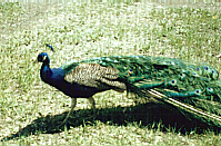 Billings was a mining and cattle town, as wide
open as the “Big Skies” motto of Montana.
Building up along the river banks between the
“rimrock”, life was hard and death came easy for
the careless or the unaware.
Billings was a mining and cattle town, as wide
open as the “Big Skies” motto of Montana.
Building up along the river banks between the
“rimrock”, life was hard and death came easy for
the careless or the unaware.
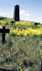 Boot Hill cemetery, so named, because so many of it’s occupants went
to their deaths with their boots on, was the burial
grounds for Coulson, the Yellowstone river town
existing from 1877 to 1885 on the edge of what
was to be Billings Montana. The most famous
person buried here was H. M. Muggins Taylor, the
scout who took news of Custer’s massacre from
the battlefield to Bozeman. He later became a
deputy sheriff in Coulson, and in 1882 was
gunned down in the laundry as he was breaking up
a domestic violence between the laundress and her
husband.
Boot Hill cemetery, so named, because so many of it’s occupants went
to their deaths with their boots on, was the burial
grounds for Coulson, the Yellowstone river town
existing from 1877 to 1885 on the edge of what
was to be Billings Montana. The most famous
person buried here was H. M. Muggins Taylor, the
scout who took news of Custer’s massacre from
the battlefield to Bozeman. He later became a
deputy sheriff in Coulson, and in 1882 was
gunned down in the laundry as he was breaking up
a domestic violence between the laundress and her
husband.
 The area was created 136 million years ago during
what is now referred to as the upper cretaceous
period, when an arm of the Pacific Ocean extended
across this regon. Shifting of the continent
resulted in a recession of the shoreline and the tide
formed beaches along the raised area. The
shoreline areas were deposits of sand and ocean
mud. Through time and the effect of erosion, the
resulting 250 to 300 foot deposits of sandstone
known as the Eagle Sandstone formation make up
the unique geological formation known as the
“rimrock”.
By the 1800’s, gold had been
discovered and the boom was on. With the arrival
of the railroad, the town grew by leaps and bounds
until it became the biggest city in Montana. Into
this development, came P.B. Moss who became
one of it’s first millionaires. A separate article has
been posted on the
Moss Mansion.
The area was created 136 million years ago during
what is now referred to as the upper cretaceous
period, when an arm of the Pacific Ocean extended
across this regon. Shifting of the continent
resulted in a recession of the shoreline and the tide
formed beaches along the raised area. The
shoreline areas were deposits of sand and ocean
mud. Through time and the effect of erosion, the
resulting 250 to 300 foot deposits of sandstone
known as the Eagle Sandstone formation make up
the unique geological formation known as the
“rimrock”.
By the 1800’s, gold had been
discovered and the boom was on. With the arrival
of the railroad, the town grew by leaps and bounds
until it became the biggest city in Montana. Into
this development, came P.B. Moss who became
one of it’s first millionaires. A separate article has
been posted on the
Moss Mansion.
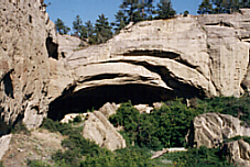 Not far out of town, overlooking the Bitter Creek,
lies Pictograph Cave State Park. A series of three
caves cut into the limestone by millions of years of
erosion. The caves overlook an area where the
Bitter Creek empties into the Yellowstone, through
the Alkali Creek, one of the few breaks in the
sandstone cliffs for a considerable distance. It is
currently believed that this was the crossing point
for the large buffalo herds and thus a common
hunting ground for Indians for thousands of years.
The archaeological finds in the caves would
indicate that they were used as a living space for
up to 5000 years ago by tribes of Indians existing
long before the Crow climbed them.
Not far out of town, overlooking the Bitter Creek,
lies Pictograph Cave State Park. A series of three
caves cut into the limestone by millions of years of
erosion. The caves overlook an area where the
Bitter Creek empties into the Yellowstone, through
the Alkali Creek, one of the few breaks in the
sandstone cliffs for a considerable distance. It is
currently believed that this was the crossing point
for the large buffalo herds and thus a common
hunting ground for Indians for thousands of years.
The archaeological finds in the caves would
indicate that they were used as a living space for
up to 5000 years ago by tribes of Indians existing
long before the Crow climbed them.
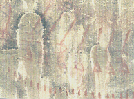 Not only
were the caves used as a living places, but the
protected cave walls were also used to record
pictures of meaningful events and spiritual topics.
Pictographs are painted images. They differ from
petroglyphs, which are engraved into the surface.
Together pictographs and petroglyphs are referred
to as rock art. Common pigments used in painting
pictographs probably included berry juices,
charcoal, earth pigments and animal fat. The most
common colors were red and black. We could find
no exact interpretation for the specific drawings
we found in the caves.
Not only
were the caves used as a living places, but the
protected cave walls were also used to record
pictures of meaningful events and spiritual topics.
Pictographs are painted images. They differ from
petroglyphs, which are engraved into the surface.
Together pictographs and petroglyphs are referred
to as rock art. Common pigments used in painting
pictographs probably included berry juices,
charcoal, earth pigments and animal fat. The most
common colors were red and black. We could find
no exact interpretation for the specific drawings
we found in the caves.
*** THE END ***
HOME PAGE