Wonderland of Rocks
Chiricahua National Monument
San Simon, AZ
March 22, 2003
For 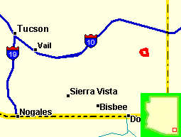 the
sun worshipers of this land, hanging out in southwest Arizona during January and
February is a normal yearly experience. It is dry, brown, and for the most
part very flat. Here, the Sonoran
the
sun worshipers of this land, hanging out in southwest Arizona during January and
February is a normal yearly experience. It is dry, brown, and for the most
part very flat. Here, the Sonoran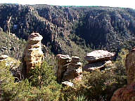 went east on I-10 until
we made a turn onto a county road and then wandered into the southeast
corner of the state and onto the lands once under the control of such infamous
Indians as Geronimo and Cochise.. Exploring
Chiricahua National Monument is like exploring a fantasy world of extraordinary
rock sculptures that were created by the forces of nature over millions of
years. Called the Land of the Standing-up Rocks by Chiricahua Apaches and later
the Wonderland of Rocks by the pioneers,
went east on I-10 until
we made a turn onto a county road and then wandered into the southeast
corner of the state and onto the lands once under the control of such infamous
Indians as Geronimo and Cochise.. Exploring
Chiricahua National Monument is like exploring a fantasy world of extraordinary
rock sculptures that were created by the forces of nature over millions of
years. Called the Land of the Standing-up Rocks by Chiricahua Apaches and later
the Wonderland of Rocks by the pioneers,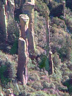 this northwest corner of the Chiricahua
Mountains harbors towering rock spires, massive stone columns and balanced rocks
weighing hundreds of tons that perch delicately on small pedestals. Where
hundreds of these rocks occur together, such as in the Heart of Rocks, the
landscape appears as a rugged badlands. The Chiricahua Mountains are a world apart from the
surrounding Sonoran and Chihuahuan Deserts. In these cool, moist, forested sky
islands, dwell many plants and animals of the Southwest and surprisingly, many
species found otherwise, only in northern Mexico. The
story behind the rocks is not completely understood, but geologists believe that
about 27 million years ago violent volcanic eruptions from nearby Turkey Creek
caldera spewed forth thick white-hot ash. The ash cooled and fused
this northwest corner of the Chiricahua
Mountains harbors towering rock spires, massive stone columns and balanced rocks
weighing hundreds of tons that perch delicately on small pedestals. Where
hundreds of these rocks occur together, such as in the Heart of Rocks, the
landscape appears as a rugged badlands. The Chiricahua Mountains are a world apart from the
surrounding Sonoran and Chihuahuan Deserts. In these cool, moist, forested sky
islands, dwell many plants and animals of the Southwest and surprisingly, many
species found otherwise, only in northern Mexico. The
story behind the rocks is not completely understood, but geologists believe that
about 27 million years ago violent volcanic eruptions from nearby Turkey Creek
caldera spewed forth thick white-hot ash. The ash cooled and fused 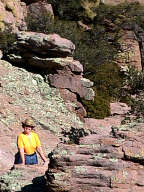 into an
almost 2,000 foot thick layer of dark volcanic rock known as rhyolite. The
Chiricahua Mountains formed from this rock upheaval, and then the master of
erosion, water, wind and ice began sculpting the rock into odd formations.
Erosion carved along week vertical and horizontal cracks creating the fascinating
rock forms preserved in the monument park. The dramatically poised rock are
great examples of how weathering is guided along the weak spots in the layers. Weathering formed the pillars along vertical cracks; the
balanced rock, along horizontal layers,
into an
almost 2,000 foot thick layer of dark volcanic rock known as rhyolite. The
Chiricahua Mountains formed from this rock upheaval, and then the master of
erosion, water, wind and ice began sculpting the rock into odd formations.
Erosion carved along week vertical and horizontal cracks creating the fascinating
rock forms preserved in the monument park. The dramatically poised rock are
great examples of how weathering is guided along the weak spots in the layers. Weathering formed the pillars along vertical cracks; the
balanced rock, along horizontal layers,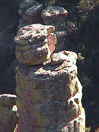 the hottest ash welded into dense, hard
rock. Other ash layers were cooler and did not weld as completely. These softer
layers eroded more rapidly, forming the narrow pedestal, undermining the large
rock mass above. In time, perhaps centuries, the softer pedestal will weather
away and the rock will tumble into the canyon.
The forces that have sculptured these towers, pillars and
balanced rocks from the
ancient welded tuffs are still at work. Erosion bites more deeply into the rock
canyons with each passing year. heating and cooling, freezing and thawing
constantly weaken and crumble the rock. I learned that even as I watched, the
rock formations around me were changing a grain of sand at a time. I tried
to visualize that single crystal of ice growing and splitting off a flake
of rock. Understanding that these tiny changes add up over the ages,
Eventually the forces will wear down the mountains until even they are only a
memory.
the hottest ash welded into dense, hard
rock. Other ash layers were cooler and did not weld as completely. These softer
layers eroded more rapidly, forming the narrow pedestal, undermining the large
rock mass above. In time, perhaps centuries, the softer pedestal will weather
away and the rock will tumble into the canyon.
The forces that have sculptured these towers, pillars and
balanced rocks from the
ancient welded tuffs are still at work. Erosion bites more deeply into the rock
canyons with each passing year. heating and cooling, freezing and thawing
constantly weaken and crumble the rock. I learned that even as I watched, the
rock formations around me were changing a grain of sand at a time. I tried
to visualize that single crystal of ice growing and splitting off a flake
of rock. Understanding that these tiny changes add up over the ages,
Eventually the forces will wear down the mountains until even they are only a
memory.