Eartha
The Biggest
Scaled Globe in the World
Yarmouth, ME
September 26, 2001
Even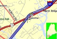 before we started living the traveling RV
lifestyle, some 5 years ago, I was concerned about navigation. I
had images, sometimes turning to nightmares of driving the rig
down a long narrow road only to find a dead end. Turning 48 feet
around on a two lane (24 foot) road is a feat I have yet to
accomplish. Sometime earlier I had acquired a Garmin 45 GPS which
I was now somewhat proficient with. This is a nifty little
electronic gadget that keeps track of where I am, by measuring
the distance from the GPS to a group of satellites orbiting
around the earth
before we started living the traveling RV
lifestyle, some 5 years ago, I was concerned about navigation. I
had images, sometimes turning to nightmares of driving the rig
down a long narrow road only to find a dead end. Turning 48 feet
around on a two lane (24 foot) road is a feat I have yet to
accomplish. Sometime earlier I had acquired a Garmin 45 GPS which
I was now somewhat proficient with. This is a nifty little
electronic gadget that keeps track of where I am, by measuring
the distance from the GPS to a group of satellites orbiting
around the earth  at
some 10,000 miles away. They sell for as little as $150. Since we
were equipped with laptops, it seemed logical to tie the GPS to a
mapping program running in the laptop, while driving down the
road. I would drive and Laura would watch the arrow on the
computer generated by input from the GPS and always know where
that bad "dead end" road was lurking, waiting for me to
drive down. During the 6 months of retirement, waiting for Laura
to be released from her job, I ordered just about every mapping
program I could find. I would play with them for a week and then
send them back. I got a pretty good idea on what was available.
My evaluation process, which excluded price as a consideration,
was sufficient to single out one particular product as superior
at
some 10,000 miles away. They sell for as little as $150. Since we
were equipped with laptops, it seemed logical to tie the GPS to a
mapping program running in the laptop, while driving down the
road. I would drive and Laura would watch the arrow on the
computer generated by input from the GPS and always know where
that bad "dead end" road was lurking, waiting for me to
drive down. During the 6 months of retirement, waiting for Laura
to be released from her job, I ordered just about every mapping
program I could find. I would play with them for a week and then
send them back. I got a pretty good idea on what was available.
My evaluation process, which excluded price as a consideration,
was sufficient to single out one particular product as superior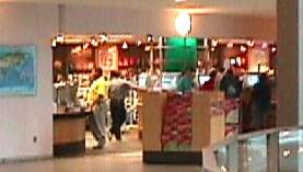 to all others available at the time. Delorme
Street Atlas seemed to have more streets, and was sufficiently
simple to allow for use without training. Needless to say we have
operated on that product and its subsequent upgrades ever since.
So, as we were passing through Maine, on our way back from the
Maritime Provinces of Canada. we had an opportunity to stop by
the Delorme corporate office and store to pick up the latest
upgrade to Street Atlas and do some browsing through all the new
neat stuff they are producing. There really was quite a bit going
on there. I particularly fell in love with the newest upgrade to
the
to all others available at the time. Delorme
Street Atlas seemed to have more streets, and was sufficiently
simple to allow for use without training. Needless to say we have
operated on that product and its subsequent upgrades ever since.
So, as we were passing through Maine, on our way back from the
Maritime Provinces of Canada. we had an opportunity to stop by
the Delorme corporate office and store to pick up the latest
upgrade to Street Atlas and do some browsing through all the new
neat stuff they are producing. There really was quite a bit going
on there. I particularly fell in love with the newest upgrade to
the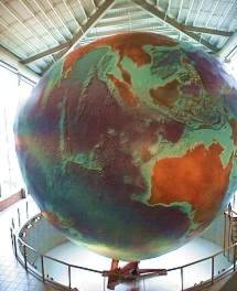 "topo" map system they have come out
with, although I couldn't justify the cost considering the
limited amount of time I spend tromping around in the woods. The
other reason for being there was to see the marvelous global
mapping construction called "Eartha". This is, I
believe the largest scaled (1:1,000,000) rotating globe of the
world in existence. It was constructed completely by Delorme
employees and completed in 1998. The globe stands in the lobby,
rising over a hundred feet. 792 panels, representing 8 degrees
latitude by 10 degrees longitude make up the surface. The surface
information taken from satellite imagery, shaded relief, colored
bathymetry (ocean -depth data) is equivalent to around 140
gigabytes of information. It weighs approximately 5600 lbs. and
covers over 5300 square feet. Eartha's movement mimics that of
Earth as it leans and circles on its cantilever arm, It rotates
on its axis at 23.5 degrees as does Earth. The speed of rotation
can be varied. Normally set to rotate every 18 minutes,
"topo" map system they have come out
with, although I couldn't justify the cost considering the
limited amount of time I spend tromping around in the woods. The
other reason for being there was to see the marvelous global
mapping construction called "Eartha". This is, I
believe the largest scaled (1:1,000,000) rotating globe of the
world in existence. It was constructed completely by Delorme
employees and completed in 1998. The globe stands in the lobby,
rising over a hundred feet. 792 panels, representing 8 degrees
latitude by 10 degrees longitude make up the surface. The surface
information taken from satellite imagery, shaded relief, colored
bathymetry (ocean -depth data) is equivalent to around 140
gigabytes of information. It weighs approximately 5600 lbs. and
covers over 5300 square feet. Eartha's movement mimics that of
Earth as it leans and circles on its cantilever arm, It rotates
on its axis at 23.5 degrees as does Earth. The speed of rotation
can be varied. Normally set to rotate every 18 minutes,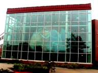 it can be increased to one revolution per
minute at maximum speed. Political boundaries were not included
making the map timeless in human terms. The conversations from
the balcony where I watched it for the full 18 minutes seemed to
center around picking out identifiable landmarks on the map and
associating them with particular countries, cities or lakes. This
is quite a showpiece, and well worth the trip out to the
business, not to mention you get to play with all that nifty
stuff on the in-house computers operating in the salesroom.
it can be increased to one revolution per
minute at maximum speed. Political boundaries were not included
making the map timeless in human terms. The conversations from
the balcony where I watched it for the full 18 minutes seemed to
center around picking out identifiable landmarks on the map and
associating them with particular countries, cities or lakes. This
is quite a showpiece, and well worth the trip out to the
business, not to mention you get to play with all that nifty
stuff on the in-house computers operating in the salesroom.
*** THE END ***