EROS
Earth Resources Observation
Systems
Sioux Falls, SD
June 7th, 2002
Having 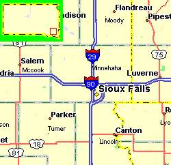 been
traveling now for some 5 years or so, we have found ourselves constantly dealing
with places we have never been and have no knowledge of the requirements of
getting around. The use of maps has become an everyday occurrence.
We even use a computerized mapping program, run on a laptop computer as we drive
along. Did you ever wonder where all that mapping information came
from? All those roads through all those towns drawn to perfect scale, and
all those topographical maps with their lines of similar elevation, so precise
in every detail? I found the answer to that question and much more at EROS
which stands for Earth Resources Observation Systems; a US government operation
with a medium strength security system. I was met at the front door by a
very well armed guard
been
traveling now for some 5 years or so, we have found ourselves constantly dealing
with places we have never been and have no knowledge of the requirements of
getting around. The use of maps has become an everyday occurrence.
We even use a computerized mapping program, run on a laptop computer as we drive
along. Did you ever wonder where all that mapping information came
from? All those roads through all those towns drawn to perfect scale, and
all those topographical maps with their lines of similar elevation, so precise
in every detail? I found the answer to that question and much more at EROS
which stands for Earth Resources Observation Systems; a US government operation
with a medium strength security system. I was met at the front door by a
very well armed guard 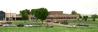 who
politely but thoroughly went through my camera case, even to the point of
requiring that the camera be turned on so he could see the image on the
back. With this out of the way I was off wandering down the long corridor
on a self guided tour. The walls were lined with photographs taken by
satellite with different magnification
who
politely but thoroughly went through my camera case, even to the point of
requiring that the camera be turned on so he could see the image on the
back. With this out of the way I was off wandering down the long corridor
on a self guided tour. The walls were lined with photographs taken by
satellite with different magnification 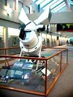 and
different light medium. There were pictures taken with infrared and ultraviolet,
and some were done using methods I had never heard of before. Acting as a
division under the U.S. Geological Survey, EROS holds one of the world's largest
collections of images of the Earth's land surface. It also has the
responsibility of distributing these images to scientists, policy makers and
educators worldwide. It is one of the five field centers operated by the
National Mapping Program of the USGS which in turn is under the Department of
the Interior. The data is gathered by two
and
different light medium. There were pictures taken with infrared and ultraviolet,
and some were done using methods I had never heard of before. Acting as a
division under the U.S. Geological Survey, EROS holds one of the world's largest
collections of images of the Earth's land surface. It also has the
responsibility of distributing these images to scientists, policy makers and
educators worldwide. It is one of the five field centers operated by the
National Mapping Program of the USGS which in turn is under the Department of
the Interior. The data is gathered by two 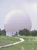 methods.
Information on the US comes from photographs taken by aircraft.
Information on the rest of the world is received through an assortment of
satellites under the control of various civilian agencies. In the middle
of the hallway was a gigantic camera once used to photograph the earth. It went
up aboard the Space Shuttle Challenger in Oct of '84. The pictures were
great but very expensive and the camera was abandoned soon after. Today
EROS manages about 8.5 million photos taken by aircraft and some 4.5 million
taken by satellite. Much of the data for satellite comes from a machine
called Landsat.
methods.
Information on the US comes from photographs taken by aircraft.
Information on the rest of the world is received through an assortment of
satellites under the control of various civilian agencies. In the middle
of the hallway was a gigantic camera once used to photograph the earth. It went
up aboard the Space Shuttle Challenger in Oct of '84. The pictures were
great but very expensive and the camera was abandoned soon after. Today
EROS manages about 8.5 million photos taken by aircraft and some 4.5 million
taken by satellite. Much of the data for satellite comes from a machine
called Landsat. 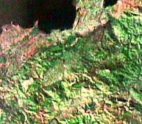 The
information is received through a giant antenna housed in a large round
structure in the rear of the building. The camera on board is so powerful that
it can obtain a resolution down to 45 feet for black and white photos and around
95 feet for color. In addition to making maps for just about anywhere, the
material gathered is used in comparison with photos taken earlier to see changes
in the Earth's surface. Such things as urban growth or the spread of a wild
fire can be quickly checked and the information passed to those with a need to
know. So the next time you pick up a road map or dial up a mapping program
on your computer think about all the work that went into just getting the
information that appears on the paper. It was an interesting place for the
technically minded and a neat way to find out just how things happen.
The
information is received through a giant antenna housed in a large round
structure in the rear of the building. The camera on board is so powerful that
it can obtain a resolution down to 45 feet for black and white photos and around
95 feet for color. In addition to making maps for just about anywhere, the
material gathered is used in comparison with photos taken earlier to see changes
in the Earth's surface. Such things as urban growth or the spread of a wild
fire can be quickly checked and the information passed to those with a need to
know. So the next time you pick up a road map or dial up a mapping program
on your computer think about all the work that went into just getting the
information that appears on the paper. It was an interesting place for the
technically minded and a neat way to find out just how things happen.
*** THE END ***