 Montana is a wonderful state, and should be on the “must
see” list of any traveler to the north west. The human
history is just short of unbelievable with its Indian
tribes and heritage, its boom towns like Billings and
Butte. Where would Zane Gray or Jimmy Stewart be without
the influence of this wide open cowboy and Indian land.
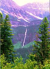
Still the greatest story every told in this land began
millions of years ago when a giant glacier carved out a
huge swath of land in the upper Waterton Valley. When the
glacier receded, wind, snow and rain, worked with the
ever present pressure of the rivers to cut the land up
into one of the most dramatic landscapes in North
America. The Glacier National Park, which makes up the
large southern part consists of 1.2 million acres and
includes 50 glaciers, 200 lakes and 700 miles of hiking
trails.
Montana is a wonderful state, and should be on the “must
see” list of any traveler to the north west. The human
history is just short of unbelievable with its Indian
tribes and heritage, its boom towns like Billings and
Butte. Where would Zane Gray or Jimmy Stewart be without
the influence of this wide open cowboy and Indian land.
Still the greatest story every told in this land began
millions of years ago when a giant glacier carved out a
huge swath of land in the upper Waterton Valley. When the
glacier receded, wind, snow and rain, worked with the
ever present pressure of the rivers to cut the land up
into one of the most dramatic landscapes in North
America. The Glacier National Park, which makes up the
large southern part consists of 1.2 million acres and
includes 50 glaciers, 200 lakes and 700 miles of hiking
trails.
The history of the park actually started back in 1818
when the 49th parallel to the continental Divide was
established as the international boundary between the
territory o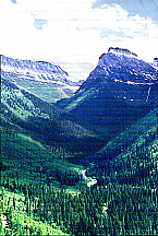 f the United States and what was at that time,
the territory owned by Great Britain. In 1895 the
northern fourth of the area became the Waterton Lakes
National Park by an act of the Canadian Congress. The lower three fourths became Glacier National Park on May
11, 1910 by an act of the US Congress. At that time
there were only a few miles of rough wagon roads. In
1932, largely through the efforts of Rotary International
of Alberta and Montana, the governments of both countries
established the first international park. The
“Waterton/Glacier International Peace Park” as it is
known today. It has been named by the United Nations, as
a “Heritage Park”. One of only seven parks in the world
to be so designated.
f the United States and what was at that time,
the territory owned by Great Britain. In 1895 the
northern fourth of the area became the Waterton Lakes
National Park by an act of the Canadian Congress. The lower three fourths became Glacier National Park on May
11, 1910 by an act of the US Congress. At that time
there were only a few miles of rough wagon roads. In
1932, largely through the efforts of Rotary International
of Alberta and Montana, the governments of both countries
established the first international park. The
“Waterton/Glacier International Peace Park” as it is
known today. It has been named by the United Nations, as
a “Heritage Park”. One of only seven parks in the world
to be so designated.
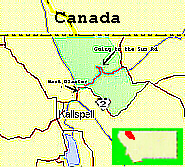
Driving up from Missoula Montana, past Flathead Lake, we
arrived in West Glacier in early evening. We pulled into
the West Glacier RV park on SR2, a privately-owned RV
park just outside of West Glacier. This was due to the
fact that, although there are a reported 1000 campsites
within the
 park, vehicles and vehicle combination longer
than 21 feet and wider than 8 feet are prohibited between
Avalanche Campground and the Sun Point parking area. Our
campsite was nice, clean and very woodsy. The next
morning we ventured into the town of West Glacier.
Somewhat commercial, with the basic necessities. Grocery
store, photo store, restaurant and bar, even a liquor
store. We continued on across the Middle Fork of the
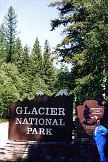
Flathead River to the entrance of Glacier National Park. We were driving on the now famous “Going to the Sun
Road”. A road that took two decades of planning and
construction to become a spectacular
park, vehicles and vehicle combination longer
than 21 feet and wider than 8 feet are prohibited between
Avalanche Campground and the Sun Point parking area. Our
campsite was nice, clean and very woodsy. The next
morning we ventured into the town of West Glacier.
Somewhat commercial, with the basic necessities. Grocery
store, photo store, restaurant and bar, even a liquor
store. We continued on across the Middle Fork of the
Flathead River to the entrance of Glacier National Park. We were driving on the now famous “Going to the Sun
Road”. A road that took two decades of planning and
construction to become a spectacular
 reality. When the
park was created, there was much disagreement over what
to do to make it more accessible to travelers. After
overcoming a move to build a road along the railroad that
bordered the south end of the park, Superintendent
William R. Logan’s dream of a transmountain road was
accepted and in 1921 Congress provided the first
appropriation specifically for the park road, in the
amount of one hundred thousand dollars.
In 1924 Frank A. Kittredge of the Bureau of Public Roads conducted a survey of 21 miles over the Continental
Divide
reality. When the
park was created, there was much disagreement over what
to do to make it more accessible to travelers. After
overcoming a move to build a road along the railroad that
bordered the south end of the park, Superintendent
William R. Logan’s dream of a transmountain road was
accepted and in 1921 Congress provided the first
appropriation specifically for the park road, in the
amount of one hundred thousand dollars.
In 1924 Frank A. Kittredge of the Bureau of Public Roads conducted a survey of 21 miles over the Continental
Divide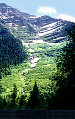 starting in September. Kittredge raced to finish
the survey before winter closed in. His team of 32 men
often climbed 3000 feet each morning to get the survey
sites. The crew walked along narrow ledges and hung over
cliffs by ropes to take many of the measurements. The
work was too challenging for some and Kittridge’s crew
suffered from a 300% labor turnover in the three months
of survey. In cooperation with the National Park
Service, the road was built with minimum impact on the
area. Bridges, retaining walls and guardrails were all
constructed of natural material from the surrounding area
Many exciting moments were spent as construction
companies working from either end worked toward Logan’s
Pass and the Continental Divide. The road was completed
with the first car passing over the 51 miles of crushed
rock road on July 15, 1933. At the official dedication
the name was changed from the Transmountain Road to the
“Going to the Sun Road”, taking it’s name from the nearby
“Going to the Sun Mountain”. It would be 1952 before the
last of the gravel would be replaced with black top.
starting in September. Kittredge raced to finish
the survey before winter closed in. His team of 32 men
often climbed 3000 feet each morning to get the survey
sites. The crew walked along narrow ledges and hung over
cliffs by ropes to take many of the measurements. The
work was too challenging for some and Kittridge’s crew
suffered from a 300% labor turnover in the three months
of survey. In cooperation with the National Park
Service, the road was built with minimum impact on the
area. Bridges, retaining walls and guardrails were all
constructed of natural material from the surrounding area
Many exciting moments were spent as construction
companies working from either end worked toward Logan’s
Pass and the Continental Divide. The road was completed
with the first car passing over the 51 miles of crushed
rock road on July 15, 1933. At the official dedication
the name was changed from the Transmountain Road to the
“Going to the Sun Road”, taking it’s name from the nearby
“Going to the Sun Mountain”. It would be 1952 before the
last of the gravel would be replaced with black top.