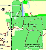
Mount St. Helens
A Volcano
Washington
August 12th, 1998
 Washington State surely has its unique place in the United
States. For several months a year, it is truly a paradise for
everyone. What would you have? The big city atmosphere of
Seattle, the Puget Sound, the Pacific Ocean, the big forests,
even the mountains. Why, you would say, nothing more than
California has to offer. Ah, but the heart of Washington State
holds it’s uniqueness within the Cascade mountain range.
Here lie the smallest of five major volcanic peaks in this
wonderful state. Mount St. Helens, with an elevation of 9,677
feet (2,950 m) (before the eruption of May 18,1980) is unique in
United States history. But I’m getting ahead of myself. We
had driven up out of Oregon, looking for adventure in the great
state of Washington. It was time for big trees, campfi
Washington State surely has its unique place in the United
States. For several months a year, it is truly a paradise for
everyone. What would you have? The big city atmosphere of
Seattle, the Puget Sound, the Pacific Ocean, the big forests,
even the mountains. Why, you would say, nothing more than
California has to offer. Ah, but the heart of Washington State
holds it’s uniqueness within the Cascade mountain range.
Here lie the smallest of five major volcanic peaks in this
wonderful state. Mount St. Helens, with an elevation of 9,677
feet (2,950 m) (before the eruption of May 18,1980) is unique in
United States history. But I’m getting ahead of myself. We
had driven up out of Oregon, looking for adventure in the great
state of Washington. It was time for big trees, campfi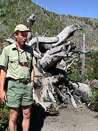 res, and a “get
back to nature” experience. We had stopped at the Ike Kinswa
state park outside of Mossyrock. The next day we took the long
drive around route 12 and stopped at the Mt. St. Helens national
park. The devastation was overpowering. As we wandered through
the desolation we came across Ranger Paul Swanson who was about
to give a talk and a walk through a section of park. He opened
his presentation by asking us to back up to March 20, 1980. After
a quiet period of 123 years, earthquake activity once again began
under the Mt. St. Helen's volcano. Seven days later, on March 27,
small phreatic (steam) explosions began. A "bulge"
developed on the north side of Mt. St. Helens as magma pushed up
within the peak. Angle and slope-distance measurements to the
bulge indicated it was growing at a rate of up to five feet (1.5
m) per day. By
res, and a “get
back to nature” experience. We had stopped at the Ike Kinswa
state park outside of Mossyrock. The next day we took the long
drive around route 12 and stopped at the Mt. St. Helens national
park. The devastation was overpowering. As we wandered through
the desolation we came across Ranger Paul Swanson who was about
to give a talk and a walk through a section of park. He opened
his presentation by asking us to back up to March 20, 1980. After
a quiet period of 123 years, earthquake activity once again began
under the Mt. St. Helen's volcano. Seven days later, on March 27,
small phreatic (steam) explosions began. A "bulge"
developed on the north side of Mt. St. Helens as magma pushed up
within the peak. Angle and slope-distance measurements to the
bulge indicated it was growing at a rate of up to five feet (1.5
m) per day. By 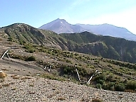 May 17, part of the volcano's north side had
been pushed upwards and outwards over 450 feet (135 m). On May
18, at 8:32 a.m. Pacific Daylight Time, a magnitude 5.1
earthquake shook Mt. St. Helens. The bulge and surrounding area
slid away in a gigantic rockslide and debris avalanche, releasing
pressure, and triggering a major pumice and ash eruption of the
volcano. Thirteen hundred feet (400 m) of the peak collapsed or
blew outwards. As a result, a debris avalanche filled 24 square
miles (62 square Km) of the valley. 250 square miles (650 square
km) of recreation, timber, and private lands were damaged by this
lateral blast. An estimated 200 million cubic yards (150 million
cubic meters) of material was deposited directly by lahars
(volcanic mudflows) into the river channels. Fifty-seven people
were killed
May 17, part of the volcano's north side had
been pushed upwards and outwards over 450 feet (135 m). On May
18, at 8:32 a.m. Pacific Daylight Time, a magnitude 5.1
earthquake shook Mt. St. Helens. The bulge and surrounding area
slid away in a gigantic rockslide and debris avalanche, releasing
pressure, and triggering a major pumice and ash eruption of the
volcano. Thirteen hundred feet (400 m) of the peak collapsed or
blew outwards. As a result, a debris avalanche filled 24 square
miles (62 square Km) of the valley. 250 square miles (650 square
km) of recreation, timber, and private lands were damaged by this
lateral blast. An estimated 200 million cubic yards (150 million
cubic meters) of material was deposited directly by lahars
(volcanic mudflows) into the river channels. Fifty-seven people
were killed 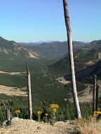 or are
still missing. For more than nine hours a vigorous plume of ash
erupted, eventually reaching 12 to 15 miles (20-25 km) above sea
level. The plume moved eastward at an average speed of 60 miles
per hour (95 km/hr), with ash reaching Idaho by noon. By early
May 19, the devastating eruption was over. After the May 18, 1980
eruption, Mount St. Helens' elevation was only 8364 feet (2,550
m) and the volcano had a one-mile-wide (1.5 km) horseshoe-shaped
crater, seen here from the northwest. For weeks, volcanic ash
covered the landscape around the volcano and for several hundred
miles downwind to the east. Noticeable ash fell in eleven states.
The total volume of ash (before its compaction by rainfall) was
approximately 0.26 cubic mile (1.01 cubic km), or enough ash to
cover a football field to a depth of 150 miles (240 km). Th
or are
still missing. For more than nine hours a vigorous plume of ash
erupted, eventually reaching 12 to 15 miles (20-25 km) above sea
level. The plume moved eastward at an average speed of 60 miles
per hour (95 km/hr), with ash reaching Idaho by noon. By early
May 19, the devastating eruption was over. After the May 18, 1980
eruption, Mount St. Helens' elevation was only 8364 feet (2,550
m) and the volcano had a one-mile-wide (1.5 km) horseshoe-shaped
crater, seen here from the northwest. For weeks, volcanic ash
covered the landscape around the volcano and for several hundred
miles downwind to the east. Noticeable ash fell in eleven states.
The total volume of ash (before its compaction by rainfall) was
approximately 0.26 cubic mile (1.01 cubic km), or enough ash to
cover a football field to a depth of 150 miles (240 km). Th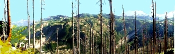 e downed trees, over
four billion board feet of usable timber, would have been enough
to build 150,000 homes. The nearly 2/3 cubic miles (2.3 cubic km)
of debris avalanche that slid from the volcano on May 18, is
enough material to cover Washington, D.C. to a depth of 14 feet
(4 m). The avalanche traveled approximately 15 miles (24 km)
downstream at a velocity exceeding 150 miles per hour (240
km/hr). It left behind a hummocky deposit with an average
e downed trees, over
four billion board feet of usable timber, would have been enough
to build 150,000 homes. The nearly 2/3 cubic miles (2.3 cubic km)
of debris avalanche that slid from the volcano on May 18, is
enough material to cover Washington, D.C. to a depth of 14 feet
(4 m). The avalanche traveled approximately 15 miles (24 km)
downstream at a velocity exceeding 150 miles per hour (240
km/hr). It left behind a hummocky deposit with an average 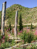 thickness of 150 feet (45 m) and a maximum thickness of 600 feet
(180 m). More than 200 homes and over 185 miles (300 km) of roads
were destroyed by the 1980 lahars. During the May 18, 1980
eruption, at least 17 separate pyroclastic flows descended the
flanks of Mt. St. Helens. Pyroclastic flows typically move at
speeds of over 60 miles per hour (100 km/hr) and reach
temperatures of over 800° Fahrenheit (400° Celsius). This was
truly one of nature’s greatest destructive acts in North
America. But like nature’s ability to destroy itself, it
most assuredly will recreate itself. Just months after the fatal
blast, the fireweed appeared. That resilient plant that sprouts
after every northwestern forest fire. Those who, having not seen
this destruction, and wishing to witness the carnage, will have
to do so within the next few decades. Otherwise nature will have
licked its wounds and recovered its devastation. Soon the
land will again be covered with spruce, cedar and alder, and all
signs except the gigantic crater will have vanished.
thickness of 150 feet (45 m) and a maximum thickness of 600 feet
(180 m). More than 200 homes and over 185 miles (300 km) of roads
were destroyed by the 1980 lahars. During the May 18, 1980
eruption, at least 17 separate pyroclastic flows descended the
flanks of Mt. St. Helens. Pyroclastic flows typically move at
speeds of over 60 miles per hour (100 km/hr) and reach
temperatures of over 800° Fahrenheit (400° Celsius). This was
truly one of nature’s greatest destructive acts in North
America. But like nature’s ability to destroy itself, it
most assuredly will recreate itself. Just months after the fatal
blast, the fireweed appeared. That resilient plant that sprouts
after every northwestern forest fire. Those who, having not seen
this destruction, and wishing to witness the carnage, will have
to do so within the next few decades. Otherwise nature will have
licked its wounds and recovered its devastation. Soon the
land will again be covered with spruce, cedar and alder, and all
signs except the gigantic crater will have vanished.
*** THE END ***