September 1st - 10th, 1998
 Since we were already up in the northwest area of Washington State we felt we
would be remiss if we did not go to Cape Flattery (which is the western-most
point of the continental United States). So in leaving Port Angeles we went west
on Route 112 towards Neah Bay stopping at a trailer park just west of a town
called Sekiu (pronounced Cee-Que).
Since we were already up in the northwest area of Washington State we felt we
would be remiss if we did not go to Cape Flattery (which is the western-most
point of the continental United States). So in leaving Port Angeles we went west
on Route 112 towards Neah Bay stopping at a trailer park just west of a town
called Sekiu (pronounced Cee-Que).
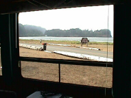
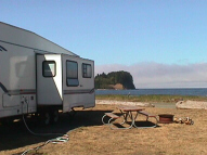 Our site was just across the street from a
primitive beach which was covered with large clumps of seaweed and driftwood.
As we checked in we received an admonition from our camp host that we were
not allowed to remove any of the driftwood along the beach for fires. Since we
had brought our own firewood it wasn’t a problem.
Our site was just across the street from a
primitive beach which was covered with large clumps of seaweed and driftwood.
As we checked in we received an admonition from our camp host that we were
not allowed to remove any of the driftwood along the beach for fires. Since we
had brought our own firewood it wasn’t a problem.
 The view of the Straits of
Juan De Fuca at this point was really lovely, while across the bay we could see
Vancouver British Columbia in the distance. After we had settled in, and armed
with a map of the area, we decided to see Cape Flattery for ourselves. Cape
Flattery is located on the Makah Indian Reservation at Neah Bay.
As we entered the Indian Reservation we noted a sign indicating that you were not allowed
The view of the Straits of
Juan De Fuca at this point was really lovely, while across the bay we could see
Vancouver British Columbia in the distance. After we had settled in, and armed
with a map of the area, we decided to see Cape Flattery for ourselves. Cape
Flattery is located on the Makah Indian Reservation at Neah Bay.
As we entered the Indian Reservation we noted a sign indicating that you were not allowed
 to
remove any types of sea shells, clams, seaweed, driftwood, or in any way disturb
nature. There was a beautiful marina that was operated by the Makah Indians for
visitors, along with several motels and RV parks. We continued on through town
to the road that went out to Cape Flattery. Well, the further out of town we went
the worse the road got. Pretty soon we started to wonder if the Conestoga
Wagons of our forefathers had heavy duty springs, because some of the ruts we
hit liked to jarred our teeth loose even with our heavy duty suspension in the
truck. Although; having driven to Silver City Idaho (outside of Boise) this road
seemed like a superhighway. Laura took the wheel in both hands and rumbled on
through. When we got to the parking lot we saw a number of cars there, so we
knew we were not the only ones looking for “bragging-rights” of standing on this
part of the U.S. There was a bulletin board at the start of the trail warning of
recent Cougar and Black Bear sightings and advising what to do if one was
sighted.
to
remove any types of sea shells, clams, seaweed, driftwood, or in any way disturb
nature. There was a beautiful marina that was operated by the Makah Indians for
visitors, along with several motels and RV parks. We continued on through town
to the road that went out to Cape Flattery. Well, the further out of town we went
the worse the road got. Pretty soon we started to wonder if the Conestoga
Wagons of our forefathers had heavy duty springs, because some of the ruts we
hit liked to jarred our teeth loose even with our heavy duty suspension in the
truck. Although; having driven to Silver City Idaho (outside of Boise) this road
seemed like a superhighway. Laura took the wheel in both hands and rumbled on
through. When we got to the parking lot we saw a number of cars there, so we
knew we were not the only ones looking for “bragging-rights” of standing on this
part of the U.S. There was a bulletin board at the start of the trail warning of
recent Cougar and Black Bear sightings and advising what to do if one was
sighted.
 By now Laura and I both had our own personal walking sticks and set
off on the trail. Setting foot into the forest made me feel like my forefathers must
have when they came this way. An awe of the beauty of nature was foremost in
our minds. Giant trees that had
By now Laura and I both had our own personal walking sticks and set
off on the trail. Setting foot into the forest made me feel like my forefathers must
have when they came this way. An awe of the beauty of nature was foremost in
our minds. Giant trees that had
 survived hundreds of years grew along both sides
of the trail. Laura decided to utilize the same method of “animal control” she had
used in Glacier National Park, and kept saying in a loud clear voice as we
walked along “HERE BEAR , HERE BEAR!” Hmmm! Funny but we never saw
a single one here either. There were several observation platforms that led off the
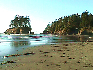
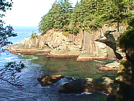
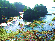
trail which had spectacular views of various inlets off the Bay. As we finally got
to the end of the trail (about ¾ of a mile) there was a raised platform that had a
clear view of Tatoosh Island with it’s lighthouse (which is located directly across
from Cape Flattery), along with some large rocks nearby.
survived hundreds of years grew along both sides
of the trail. Laura decided to utilize the same method of “animal control” she had
used in Glacier National Park, and kept saying in a loud clear voice as we
walked along “HERE BEAR , HERE BEAR!” Hmmm! Funny but we never saw
a single one here either. There were several observation platforms that led off the
trail which had spectacular views of various inlets off the Bay. As we finally got
to the end of the trail (about ¾ of a mile) there was a raised platform that had a
clear view of Tatoosh Island with it’s lighthouse (which is located directly across
from Cape Flattery), along with some large rocks nearby.