The Natchez Trace
Traveling along the Parkway
Tennessee, Alabama and Mississippi.
January 12th, 1998
Traveling along the Parkway
Tennessee, Alabama and Mississippi.
 There is an old expression around the Mississippi river that says that Mississippi was
created when it blew in from Texas on a windstorm some 20 million years ago, and in the
area where the Trace lies, it would seem possible as there are very few if any rocks in the
area. The ground is soft and deep. The Natchez Trace is a pathway that very well may be
as old. Most assuredly an animal path in the beginning, it was commonly used by anybody
and anything moving north or south through the territory.
There is an old expression around the Mississippi river that says that Mississippi was
created when it blew in from Texas on a windstorm some 20 million years ago, and in the
area where the Trace lies, it would seem possible as there are very few if any rocks in the
area. The ground is soft and deep. The Natchez Trace is a pathway that very well may be
as old. Most assuredly an animal path in the beginning, it was commonly used by anybody
and anything moving north or south through the territory.
 As time passed the ground
gave way to the repeated pounding of animal and man, and a kind of trench appeared
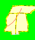
sometimes 20 feet deep. For almost 450 miles it stretches from Natchez Ms. to just south
of Nashville TN. meandering past lakes, rivers and rich farm lands. The Chickasaw and
Choctaw Indians were the first humans to utilize this pathway as they plied there trade up
and down the trail. The French and then the Spanish came, and the trace became a place
of importance in the movement of these new white men who spread their influence across
the South.
As time passed the ground
gave way to the repeated pounding of animal and man, and a kind of trench appeared
sometimes 20 feet deep. For almost 450 miles it stretches from Natchez Ms. to just south
of Nashville TN. meandering past lakes, rivers and rich farm lands. The Chickasaw and
Choctaw Indians were the first humans to utilize this pathway as they plied there trade up
and down the trail. The French and then the Spanish came, and the trace became a place
of importance in the movement of these new white men who spread their influence across
the South.
 As early as 1733 the French were familiar enough with the land to make a map
that showed an Indian trail running from Natchez to the Northwest. By 1785 American
settlers in the Ohio River Valley had established farms and, in search for new markets, had
begun floating their crops and products down the rivers to Natchez and New Orleans. As
the steam engine was yet to be invented, the trips down the river were one way.
As early as 1733 the French were familiar enough with the land to make a map
that showed an Indian trail running from Natchez to the Northwest. By 1785 American
settlers in the Ohio River Valley had established farms and, in search for new markets, had
begun floating their crops and products down the rivers to Natchez and New Orleans. As
the steam engine was yet to be invented, the trips down the river were one way.
 The flat boats, having reached their destination, were broken up and sold for wood.
The boatmen who had spent months riding them from the upper river ports were paid off and
were on their own to get by home by whatever means were available.
The Natchez Trace was the
most direct route. This rowdy group of hard drinking, hard working men found
themselves without roads as they reached Natchez heading north. Their best choice was
to walk the remaining 450 some odd miles to Nashville where there was a poor but usable
network of roads capable of transporting them to their northern destinations. As the
number of boatmen grew, the crude trail was tramped into a clearly marked path.
The flat boats, having reached their destination, were broken up and sold for wood.
The boatmen who had spent months riding them from the upper river ports were paid off and
were on their own to get by home by whatever means were available.
The Natchez Trace was the
most direct route. This rowdy group of hard drinking, hard working men found
themselves without roads as they reached Natchez heading north. Their best choice was
to walk the remaining 450 some odd miles to Nashville where there was a poor but usable
network of roads capable of transporting them to their northern destinations. As the
number of boatmen grew, the crude trail was tramped into a clearly marked path.
 Over the years improvements were made and by 1810 the Trace was an important wilderness
road, the most heavily traveled in the Old Southwest. The rough and ready boatmen, their
pockets filled with the last remaining money paid for their trip down, now became the
target for prostitutes gamblers, thieves and hostile Indians who waited along the way.
Many books have been written about the harrowing adventures of these frontiersmen as
they traveled north over the Trace.
For protection and comfort, small buildings which
became known as "stands" appeared along the Trace and by 1820 there were 20 or so in
operation.
Over the years improvements were made and by 1810 the Trace was an important wilderness
road, the most heavily traveled in the Old Southwest. The rough and ready boatmen, their
pockets filled with the last remaining money paid for their trip down, now became the
target for prostitutes gamblers, thieves and hostile Indians who waited along the way.
Many books have been written about the harrowing adventures of these frontiersmen as
they traveled north over the Trace.
For protection and comfort, small buildings which
became known as "stands" appeared along the Trace and by 1820 there were 20 or so in
operation.
 In most cases these stands provided nothing more then a roof over their heads
and plain food, often being run by ex-riverboat men who had married Indians. In 1812 the
first steamboat, the New Orleans, arrived in Natchez and spelled the end of a way of life
along the Trace. Travelers elected the speed and comparative safety of steamboats over
the hot steamy footpath they were use to. Soon the bustle of the Trace faded and the
peaceful life of the natural forest returned.
In most cases these stands provided nothing more then a roof over their heads
and plain food, often being run by ex-riverboat men who had married Indians. In 1812 the
first steamboat, the New Orleans, arrived in Natchez and spelled the end of a way of life
along the Trace. Travelers elected the speed and comparative safety of steamboats over
the hot steamy footpath they were use to. Soon the bustle of the Trace faded and the
peaceful life of the natural forest returned.
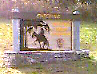
 By 1930 the Trace was all but forgotten as a
mode of travel, much of it having been converted to farmland. The National Park Service
constructed a parkway over the entire distance, following as closely as possible the exact
path of the Trace. Today more the 90 percent of the parkway has been completed, with many
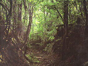
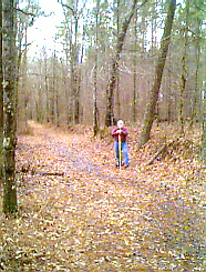
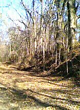
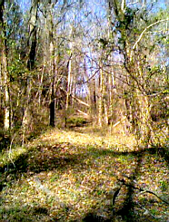
points of interest and several points where you can stop and walk along the old trace,
much as those early pioneers did. The parkway itself is a well kept two lane blacktop
which is actively patrolled by park police. There are many precautions specifically when
walking along the old Trace. Poison ivy, fire ants and ticks all thrive along the way.
Watchful driving is needed as the entire parkway is a game preserve and when evening
approaches small herds of deer commonly appear along the side of the road.
By 1930 the Trace was all but forgotten as a
mode of travel, much of it having been converted to farmland. The National Park Service
constructed a parkway over the entire distance, following as closely as possible the exact
path of the Trace. Today more the 90 percent of the parkway has been completed, with many
points of interest and several points where you can stop and walk along the old trace,
much as those early pioneers did. The parkway itself is a well kept two lane blacktop
which is actively patrolled by park police. There are many precautions specifically when
walking along the old Trace. Poison ivy, fire ants and ticks all thrive along the way.
Watchful driving is needed as the entire parkway is a game preserve and when evening
approaches small herds of deer commonly appear along the side of the road.
*** THE END ***